Introduction
With over half a million New Zealand businesses connected to IoT and approximately 13.1 billion connected devices worldwide, global coverage through satellite technology is becoming increasingly necessary. Traditional terrestrial networks have significant limitations. Only 10% of Earth's landmass is served by cellular towers, making remote connectivity extremely challenging.

The Satellite Revolution
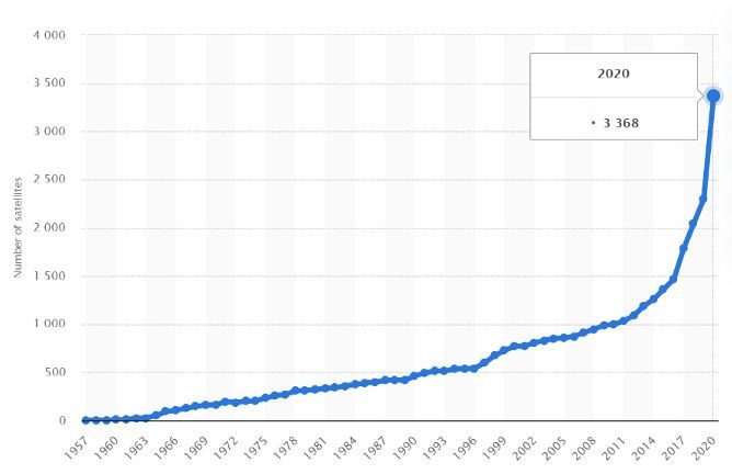
The emergence of cheaper access to orbit and miniature satellite technology has sparked an explosion of satellite launches. The number of active satellites more than doubled between 2017 and 2021. Major telecommunications providers like Starlink, OneWeb, and Amazon's Project Kuiper are racing to bring high-speed broadband to isolated areas globally.
However, IoT applications represent only 2% of current satellite coverage revenues. This gap creates opportunities for established providers such as Inmarsat, Iridium, ORBCOMM, and Globalstar, which account for over 80% of the IoT satellite market and are expected to hold approximately 20% of the global market by 2026.
Technologies for Satellite IoT
Three orbital types support satellite IoT: LEO, MEO, and GEO. All function similarly. IoT devices transmit data to satellites, which relay it to ground stations, then to end-users via the internet.
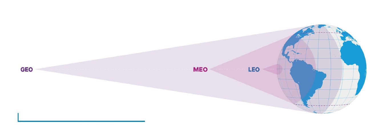
LEO Satellites
LEO (Low Earth Orbit) satellites dominate IoT applications for several reasons:
- Low Power Requirements: Operating at 200-2,000 km altitude requires minimal transmission power
- Simplicity: Reduced signal strength demands enable simplified designs and cost-effective cube-sat manufacturing
- Affordability: Lower deployment costs and faster placement in orbit; one orbit takes 90 minutes
Only two-thirds of LEO operators have launched satellites. High fixed costs and low variable costs create economic challenges, with some operators like Hiber abandoning independent launches.
GEO Satellites
Geostationary satellites remain stationary above Earth's surface by matching the planet's rotation at approximately 36,000 km altitude. They offer large coverage areas but face significant drawbacks for IoT:
- High latency (~250ms)
- Powerful signal amplification requirements
- Line-of-sight requirements
- High service and launch costs
GEO satellites excel for critical networks requiring ultra-reliability and large data transfers, thanks to their large solar panels and powerful antennas.
MEO Satellites
Medium Earth Orbit satellites operate between 10,000-20,000 km altitude, offering a compromise between LEO and GEO characteristics: lower latency than GEO, greater coverage than LEO, and continuous coverage. However, high launch costs and complex satellite requirements limit IoT applications.
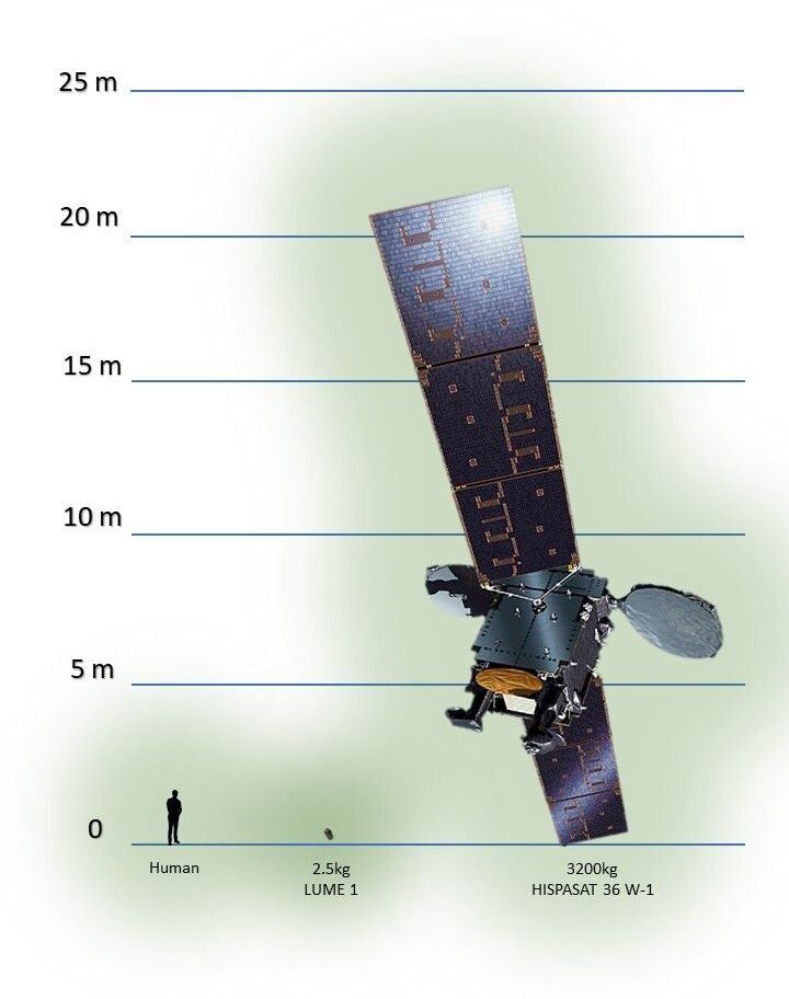
Micro Satellites
Companies have developed progressively smaller satellites to reduce IoT service costs:
- Microsatellites: 10-100 kg
- Nanosatellites: 1-10 kg
- Picosatellites: 0.1-1 kg
- Femtosatellites: <0.1 kg
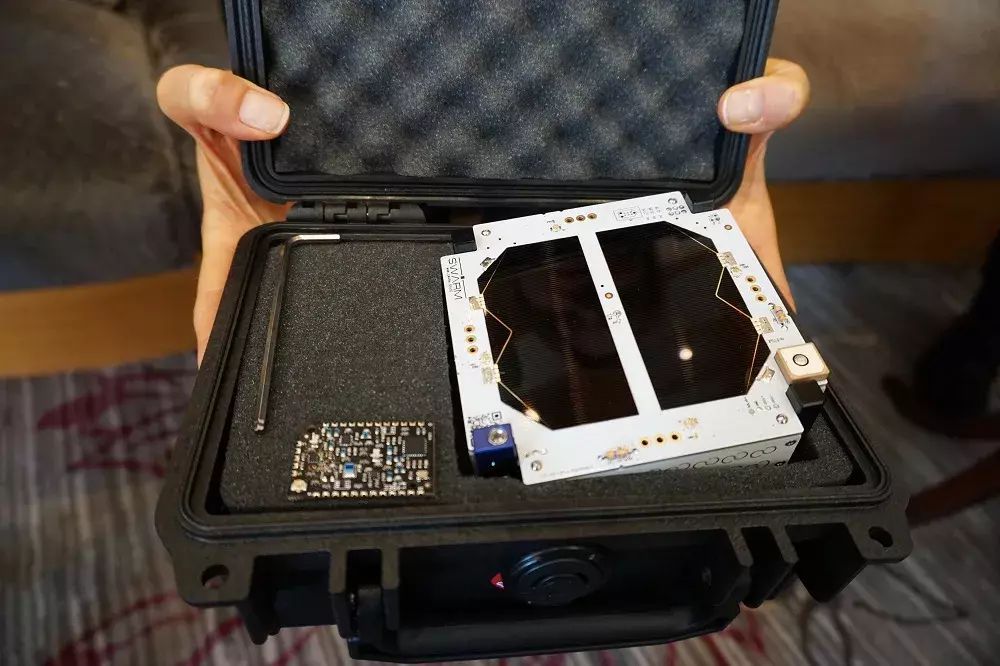
Swarm Space operates the smallest global IoT satellites in orbit (11 x 11 x 2.8 cm, approximately 400 grams). Their pricing beats competitors by factors of ten to one hundred. Current Swarm plans cost as little as $5 USD monthly, offering 750 data packets per month at up to 192 bytes per packet plus 60 downlink packets, sufficient for weather measurements and location tracking.
Other manufacturers including Pumpkin Space Systems, EnduroSat, and AAC Clyde Space are actively producing these tiny satellites.
Conclusion
The satellite IoT market is rapidly expanding yet remains crowded and competitive. Industry experts predict many competitors will fail, with survival limited to a few major players. LEO satellite technology is expected to dominate the future due to its inherent advantages.
LEO satellites enable diverse applications including real-time GPS-based mapping and tracking for ships, aircraft, vehicles, and weather forecasting. These applications span agriculture, transportation, and military operations, making satellite technology essential to modern life.
Beta Solutions has experience designing electronic solutions integrating GPS functionality for tracking, mapping, and location-based services. Contact us for projects requiring these capabilities.